
So, I don’t know how to start this trip report.
Do I explain what led to Lana and I trail running 50+ miles in the Olympic Mountains?
Do I exude endless amounts of gratitude for our amazing Sherpas, Chris and Jeremy, who supported this idea?
Do I take my father’s advice and undergo psychological analysis to check my mental state?
Let’s start from the beginning.
Many of the wonderful things that have happened to me in 2019 have all started with Lana – my running partner, a former park ranger, a fellow lady mountain rescue member, and an amazing mom, who has been a great inspiration to take our trail running to new distances and heights this year.
Literally.
On May 6, 2019, two days after her first marathon, between 2:31 p.m. and 2:56 p.m., the following conversation happens over text:
Lana: Would you like to trail run with me late August one night? In Elwha, out the North Fork Quinault.
Me: That’s across the Olympics! *pause* That would be crazy awesome!
*Chatter about gear and logistics*
Lana: I’m obviously excited about this idea since I’m blowing up your phone.
Me: Yeah and it’s not taking much for me to be convinced LOL
Over the next three months, gear is discussed, routes are explored and decided upon, and training ensues. Aside from our individual training, we crank out long runs together, such as an easy out-and-back 15-miler from Obstruction Point to Deer Park; gleefully run up the Upper Dungeness to Marmot Pass and out Tubal Cain with surprising ease (and more miles than we intended).
At Marmot Pass:
Me, looking at the map for the rest of the route: Um, we have more than we thought to Tubal Cain. It’s nine miles.
Lana: Really. Huh.
Me: Yeah. Huh.
We then continue eating our lunch, not fazed in the least about our extended mileage.
It was at that point I realized I truly fell in love with this sport. Nine miles of backpacking? My feet ache just thinking about that. Nine miles of cruising on flowy single track? I don’t bat an eye.
Logistics discussions continue and word gets out what we’re planning. Chris pipes up and says, hey, I’d like to backpack that area and could use some trail miles. I’d support you guys by bringing in overnight gear if you want.
Jeremy steps up and says, yeah, I could use a big backpacking weekend. I’ll sherpa too.

Lana and I couldn’t believe our luck. Game. Changer.
The final agenda:
Saturday morning: In Graves Creek Trailhead at Quinault
Saturday night: Meet the guys and camp at Marmot Lake, via Ranger Pass/LaCrosse Basin
Sunday afternoon: Run out the Duckabush River Trail
= 42 miles.
Friday, August 16:
The Lorenz and Myers families bring Tiffany and Lana to the Graves Creek campground at Quinault to camp at the trailhead that evening.
The Sherpa Team goes to Staircase Rapids and hikes in 10 miles that night via North Fork Skokomish Trail and camps at Nine Stream.
Saturday, August 17:
8:45 a.m.: The Lorenzes and Myers send off Lana and Tiffany into the mountains with hugs and farewells (except for one 4-year-old who was NOT pleased her mom was going into the mountains without her) and they sprint into the woods with yelps and whoops of excitement.


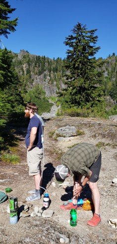
The Sherpa team makes its way from Nine Stream to Marmot Lakes, over 12 miles and 4,000 feet, where they set up camp in the late afternoon, ready with hugs, whiskey and chocolate.
Our plan was to run/power hike a relatively rolling total of 22 miles on Saturday, from Graves Creek Trailhead through Enchanted Valley, start climbing 3,000 feet at the O’Neil Pass Trail junction, jump off trail in White Creek Basin to go up to Ranger Pass, go down into Lacrosse Basin, and pick up the waytrail to Marmot Lakes to camp.
Previous experience had shown that Lana and I could rack up miles faster than we expected, which was no different on this day. Lana used to ranger in this area too, so I got stories about adventures she had with visitors, rangers, wildlife and good places to camp.
Despite taking it easy the past few weeks and watching a few weird tweaks and injuries I’d endured this summer, ALL OF THEM DECIDED TO SPEAK UP AT ONCE ON SATURDAY.
Which was my biggest fear. Because I really didn’t want to turn around.
Thankfully, Lana and I are pretty good at listening to our bodies and deciding when to pull back and when push forward. I knew I just needed to run through some of it to warm up. By mile 8 or so, and some ibuprofen, things had calmed down and we had settled into a power hike/run flow, making our way through rolling terrain of meadows, maple tree groves, and fern bowls under canopies of old cedars.


Before I knew it, we were at the Enchanted Valley gate at 13.1 miles, which I thought would be some nifty and artfully created wood structure that greeted visitors to the famous and highly coveted Enchanted Valley area. (The above is not it.)
Nope. It is literally a gate to keep stock, such as work horses and mules, from going down trail. Apparently, if a horse isn’t tied up and wants to go back to its barn, it will just start marching home, no matter how long or how far it is.
It was apropos to learn this, as the phrase of the weekend was, “I’m just going to be a horse to the barn,” when one of us would talk about getting to the next destination point.
We got into the valley, which I’d never been to before and was half the reason I said yes to this trip, because of its beauty and remoteness and magic. For being 13.1 miles into the backcountry, it was full of people milling about – setting up camp, stretching, swimming, napping.

Also, the chalet on the Quinault River bank. The valley is famous for this beautiful and bomber two-story building that was constructed in the early 1900s for rangers and visitors. Lana regaled me with stories of her stays there, working on the old water systems and the Irish wood stove, how she’d come into shut down the chalet for the season, and the elk herds and bears she would see in the meadow. However, the Quinault River is shifting, as rivers do, and it’s threatening to take out the chalet. The structure has been moved from the river bank already once before, and rumor has it that, sadly, the park is just going to let nature take her course.
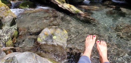
After a few minutes in the valley, we made our way up trail, stopping for lunch, a water refill and a good foot soak in the river. I’m not much for foot soaks and hot tubs and ice baths, especially when it involves having to take off my shoes, waiting for things to dry and then putting them all back on.
But damn that mountain river water saved my feet during this trip several times. Something about numbing the pain and then allowing new blood to rush to the feet again.
After the valley, we started climbing toward the O’Neil Pass Trail/Anderson Pass junction. It was about 2 or 3 p.m. and we were about 16 miles in. We had 3,000 feet and 5-7 miles to go until camp. We were hoping to get there between 5-6 p.m.

The O’Neil Pass Trail isn’t anything special – other than it was established by Lt. Joseph P. O’Neil who led a military expedition into the Olympics in July 1890. But today, it’s a climbers trail. Slightly overgrown with brush and invisible holes lining the downhill side of the trail that your feet find first before your head does.
The trail follows White Creek. Once we got to the junction where the trail crosses the hairpin turn in the creek, we jumped off trail and started making our way toward this huge wall of scree that had several notches at the top of the wall, one of which was Ranger Pass.

We were going to climb up and over Ranger Pass to get to Lacrosse Basin. But as we got higher and higher onto the scree field, the cloud layer started to lower.
And lower.
And lower.
And soon we were socked in and couldn’t see more than 100 feet in front of us.

The view of our objective had disappeared. And we suddenly found ourselves on HUGE snowfields that were NOT AT ALL in view from the creek down below.
WTF happened?
At this point, it was 6 p.m. or so. We were constantly checking our maps and our GPS devices, and discussing potential options for the rest of the day:
- Tell the Sherpa Team (with whom we were communicating over the InReach, that blissful Personal Locator Beacon/GPS device that has saved MANY lives in the mountains the past few years) to climb up Lacrosse Basin and yell down from the ridge and we’d follow their voices (the ridge was only two miles from them).
- Bivy down in White Creek basin.
- Continue traversing left. Or right.
- Go back down to O’Neil Pass trail and take the long way to Marmot Lakes.
The initial plan of going cross country over Ranger Pass was to avoid these additional 8 miles to Marmot Lakes, making our 20ish mile day into a 30ish mile day. Lana had done the cross country route before, so she knew it would go once we found the right notch.
However, we didn’t account for the whiteout. Thank you, Olympic Mountains. You lived up to your reputation, once again.
After hemming and hawing and traversing back and forth across the scree field some more, we called it at 7:30 p.m. and decided to slog on trail for more miles than scramble a scree field where we couldn’t see where we were going.
We sent a message to the guys about our new plan and they responded with “Good copy. We’re on our way with warm clothing, food and water.”
YAY!
Once we turned around and headed down, our defeated spirits changed suddenly, looking forward to the moral support of the Sherpa team, who worked insanely hard to get in here.
We got back down to O’Neil Pass Trail around 8:30 p.m. and started the trail slog.
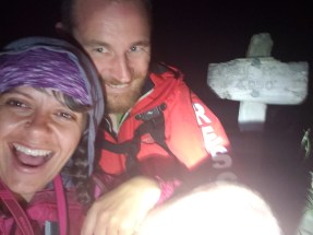
Around 9:30, in the dark with headlamps, as we’re shuffling along half awake, mumbling nonsense to each other while trying not to fall off the trail, we see two headlamps come around the corner.
“I see them.” Lana says, who was so tired she couldn’t muster up excitement in her voice. I just made some loud yelp that was clearly supposed to communicate that I was happy to see them.
After they plied us with food and warm clothing and water, our spirits were restored and we start to make our way back toward camp … for five miles.
Lana warned us that the O’Neil Pass trail is one of those routes that feels like it never ends, and did it ever. Plus, overgrown brush and steep drop-offs to the right.
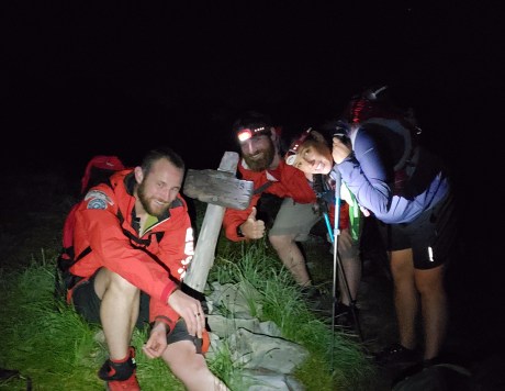
After 4 miles and at 11:30 p.m., we finally hit the clearing that was O’Neil Pass. The clouds had lifted, the stars were out, and the moon illuminated the ridge line of the mountain range that surrounded us. It was a pretty spectacular view.
We stopped for a quick break and the crew indulged me in a photo session with the pass sign – as best as one can do with only headlamps and camera phones.
Side note:
This guy.
We started dating, oh, back in July (we think, the official date is still up in the air; he spent weeks wooing me and I spent weeks thinking about it, but we’ve known each other since 2013). There are not enough words to describe this guy. I respect him, I adore him, I’m impressed by him, I’m swooned by him, I’m entertained by him. We can pretty much predict what the other is thinking and it is all unbelievably easy and comforting and amazing.
I deserve him. He deserves me.
We are incredibly excited for our future adventures.
And I was STOKED to hear his voice at 9:30 Saturday night on the O’Neil Pass Trail.
—-
We slogged our way back down to camp, ate some chocolate and whiskey and called it dinner, then crawled into our bivys and passed out for the night.
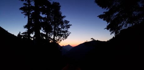
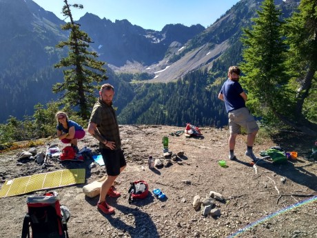
The guys set up the tents and bivys facing east, so we all had a fantastic sunrise view. I was up at 5:30 a.m. and walked around camp taking pictures of the early morning twilight, then crawled back into bed to snooze until about 7.
We had a leisurely morning, eating breakfast and packing up, despite the 20+ miles we had ahead of us. It was one of the best backcountry camp mornings I’d had in a very long time though. Mainly because while I was still exhausted (I reached the point of crying and laughing while trying to share crackers with Jeremy but instead I dumped them in my shoes and on the ground, then tried sharing with him again. “Worst Girlfriend Ever,” he quipped. That just made me laugh harder.), but beyond the moon happy to be there with these people, as well wake up to blue skies and sunshine in the mountains.
Chris, the water buffalo.
Originally, the plan was for the guys to hike back to Staircase, but with the massive elevation gain/loss they had coming in, they realized if they went out with us, they’d only have 500 feet elevation gain/loss over the same distance. So, it was a no brainer, with 35 lbs. + packs, to go out the easier route. We’d just have to drive an hour to get Chris’ car at the Staircase trailhead.
It was nice to have them along for the adventure out, both as company and moral support, the latter for both parties really, as they were just as exhausted as us. The hike out was pretty uneventful, just long. We would establish a meeting point for a break, such as Upper Duckabush Camp and 10 Mile Camp, since we were all going different paces, but stayed mostly within about 10 minutes of each other.
Well, actually, I suppose being chased by ground wasps made the first third of the day eventful. Typically, whoever was in the lead would see the bee and yell, then do a wild cartoon dance to chase them off but likely get stung, while the rest of us would retreat and run the other way, then bushwhack around the general area and jump back on trail. Regardless of our attempts, three of the four of us got stung, but thankfully no allergic reactions. But LOTS of swelling and itching the following week.
Finally, around 8 p.m. Sunday, after climbing up and over Big Hump and Little Hump, then dragging our feet for what felt like an ENDLESS couple miles, we stumbled off the trail and into the parking lot at the Duckabush Trailhead, where we each threw down our packs, sat on them and just stared at the ground, internalizing what we just did. We mumbled things to each other such as, “who wants a beer” or “here, salt and vinegar chips.” Some of us changed, some of us just collapsed into the car. Before long, we were back on the road.
And just like that, the three-day, 40 Mile-Turned-50 Mile adventure came to an end. Exhausted, thrilled and accomplished.

I think a big part of the satisfaction from this trip was not just our mileage but also the company. Each of us are current or past members of Olympic Mountain Rescue, which holds a special place in each of our hearts. We regard the organization like family, and this trip seemed like an extension of that feeling.
Not sure how to end this trip report, other than acknowledging that I (and I know Lana too) cannot express enough gratitude to Chris and Jeremy for their physical, moral and emotional, support for the trip. We know we could have done it on our own, but it was so much more fun with you guys. Thank you, Thank you, Thank you.
Quick, someone call REI or Outdoor Research. We’re ready for the Spring 2020 catalog shoot.
And finally, of course, thank you to Lana, for her adventurous spirit that led us to this amazing and memorable weekend! The force of mountain life is strong with this one.
